Gorges to hike and walk near Ágios Pávlos, in Rethymno region

List of Gorges near Ágios Pávlos

  • 9.9 km
  • Swallows' Gorge
  • 6.5 km
  • 4 h
  • Hiking

The Swallow Gorge, situated 33km south of Rethymnon city, is in close proximity to the renowned Preveli beach, known for its magnificent palm grove and breathtaking river. The gorge begins from Kenda peak (881m altitude), passes through Drymiskos village, runs nearly parallel to the Kourtaliotiko canyon, and concludes at Drymiskiano Ammoudi beach. It gets its name from the swallows that flock here every summer.

Unlike Kourtaliotiko, this lesser-known canyon is dry during the summer but is still worth a visit. The vertical, awe-striking rocks and the verdant riverbed (which flows in winter) are a sight to behold. The winding Swallow Canyon is relatively easy to hike and doesn’t require any specific skills, despite not being marked.

A significant portion of the canyon runs parallel to the road leading to Amoudi beach, which is where the easy trail to Preveli begins. To find this road, take a left at the picturesque arched bridge of Megalos Potamos that you’ll come across en route to the Preveli monastery. Therefore, even if you’re not much of a walker, you can still enjoy the beauty of the gorge during your visit to Preveli.

  • 11.1 km
  • Kissos Gorge
  • 1 km
  • 1.5 h

Located just 1km north of Kissos village in Agios Vasilios province and 34km southeast of Rethymnon, Kissano Gorge serves as a link between Kambos Kissou settlement and the small Gious Kambos plateau. The gorge’s river is a primary tributary of the Gorge Frati. The canyon, though not lush with vegetation, boasts small waterfalls, the tallest of which measure between 5-7m. These waterfalls make it an ideal location for canyoning, but it’s also possible to bypass them carefully from the sides without any specialized equipment.

The journey begins at the Gious Kambos plateau, a small haven of diverse flora. A 0 to 30-minute walk along or beside the riverbed leads you to a point where the river intersects the road connecting Kissos with Gerakari. Here, you’ll find a striking reddish rock peppered with numerous caverns known as Kokkinos Detis, leading locals to also refer to this area as the Kokkinos Detis Gorge.

While this marks the end of the main part of the canyon, the river continues its descent, creating more small waterfalls. It then passes through the 60-hectare artificial pine forest of Vatolakki, before continuing towards Spili and eventually to Frati.

  • 11.6 km
  • Agia Fotia Gorge
  • 1 km
  • 1.5 h
  • Hiking

Approximately 1 km to the east of Spili, in the Agios Vassilios province, you’ll find the church of Agia Fotini, also known as Saint Photini. Like many places in Crete, it’s often referred to as Agia Fotia. Situated on the main road leading to Agia Galini, the church is adjacent to a spring that flows with water throughout the year. Nearby, you’ll see a large, old watermill. This area marks the end of the picturesque Agia Fotia gorge, which is small but incredibly lush.

The gorge begins at the Gious Kambos plateau, which is 750m above sea level, and concludes at the spring, which sits at an altitude of 500m, after a 1.5km journey.

Close to the gorge’s starting point, you’ll discover waterfalls of unparalleled beauty. In the springtime, these falls are abundant with water, creating a unique and breathtaking landscape filled with plane trees. The easiest way to reach the waterfalls is by walking from the spring along the gorge. Alternatively, you can access them from Gious Kambos, though this route is more challenging. It requires bypassing the waterfalls from the sides and descending the steep slope to the riverbed.

  • 13.2 km
  • Gorge Kinigospilios at Hordaki

In the quiet, almost abandoned village of Chordaki, located in the Amari district, we discovered the hidden gem of Kynigospilios Canyon. Situated south of the village, this small but stunning canyon remains a secret, its location hidden from view, which contributes to its relative obscurity. The Kynigospilios Canyon boasts a significant water flow from the slopes of Mount Kedros, which lasts from winter through to late spring.

However, traversing the canyon requires the use of ropes and canyoning equipment due to the presence of eight stunning waterfalls along its path, with the last one being particularly breathtaking. Unfortunately, the canyon’s safety measures, installed by canyoners around 2011, are not ideally positioned, making them inaccessible during periods of high water flow. The canyon was christened ‘Koutsouna’ (meaning ‘small’) by the first group to cross it, as they couldn’t find an existing name for it.

At the canyon’s entrance, you’ll find two adjacent watermills, and the surrounding area is lush with greenery, including platans and oaks that provide ample shade. Beneath most of the waterfalls, you’ll find ponds perfect for swimming in the canyon’s crystal-clear river waters. The Kynigospilios Canyon eventually merges into the Platys River bed at its termination point.

  • 13.8 km
  • Smiliano Gorge (Kalamafka)
  • 2.5 km
  • 3 h

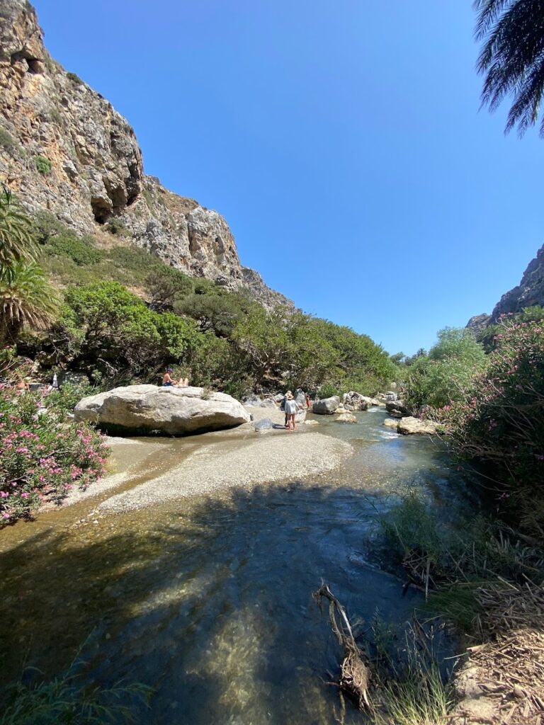
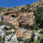
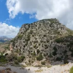
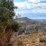
Located approximately 100km southwest of Heraklion city, north of Ano Meros village, you’ll find the Kalamafka or Gorge Smiliano. The Lygiotis river, originating from the Gerakari valleys and the Samitos Mount slopes, flows through this gorge. The 2.5km long canyon begins near Vrysses village, close to the deserted settlement of Smile, and concludes north of Ano Meros, accessible via an asphalt road.

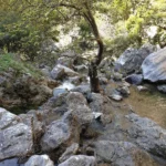
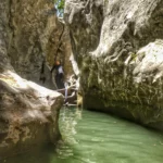
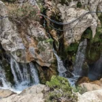
During winter, the gorge is filled with water, making entrance risky even for experienced canyoners. However, an alternative route via a dirt road descending from Drygies village leads just above the gorge. Here, the canyon’s steep walls form a slope with a trail, allowing relatively easy descent to the gorge’s heart, precisely at the point where the stunning waterfalls are formed continuously. The gorge comprises about 10 remarkable rappels, with the tallest waterfall being 13 meters. The ponds formed beneath each waterfall are equally breathtaking, and it’s worth noting that Gorge Smiliano boasts the largest and deepest ponds compared to any other gorge in Crete.

A journey through the canyon (as described in June of a particularly rainy year)
Starting near Smile, we first cross a small arched bridge. After just 50m, we enter the gorge’s main section, greeted by a large pond. The canyon then narrows to about 2m and forms a deep pond, 2-3m deep, requiring swimming. The first small rappel we encounter ends in a large, deep pond (perfect for jumping), where the depth exceeds 3m.

Following this, a rock lodged between the canyon walls forms a natural arch. After swimming for several meters (over 25) without touching the ground, we continue our journey unimpeded. We soon encounter the first high waterfall, and the gorge narrows further (1-1.5m). To continue through this narrow section of the canyon, ropes are required. Alternatively, we can walk alongside the canyon until we reach the 15m high rappel that ends in a very deep pond, perfect for a big jump.

The gorge extends eastward, and the deep ponds gradually become small, shallow ponds. Towards the end of the gorge, the water almost disappears, making it impossible to anticipate the aquatic paradise that lies just a few meters ahead.

  • 13.8 km
  • Kourtaliotis Gorge at Preveli
  • 7 km
  • 4 h
  • Hiking

Situated 22km south of Rethymno, Kourtaliotis Gorge, with its stunning 3km length, stands as one of Rethymno’s most breathtaking natural wonders. The gorge originates from the village of Koxare, weaving its way between the towering Kouroupa and Koules mountains of the Xiro Oros range. The dramatic cliffs of the gorge, reaching heights of up to 600 meters, house numerous caves and openings, offering a home to a variety of unique fauna.

This majestic landscape is adorned by the Kourtaliotis River, which continues its course until it merges with the Frati Gorge and ultimately leads to Lake Preveli, taking on the name Megalos River in its final stages.

The beauty of this gorge can be experienced by following a paved road that cuts through the canyon. Steps from the Koxare-Asomatos street will guide you to the gorge’s base, where you’ll find the chapel of the local Saint Nicholas Kourtaliotis. One of the standout attractions here are the springs of Kourtaliotis, nestled near the chapel. Further exploration reveals Kourtaliotis’ stunning waterfall, accessible by swimming from a lower river level, leading to a darker, narrower part of the gorge.

A trek along the river takes you to the Megalos River bridge and onwards to Preveli’s palm beach. Kourtaliotiko gorge is a treasure trove of aesthetics, biodiversity, and ecological significance. Beyond its dense Cretan Date Palm trees, the second-largest palm forest on Crete, the gorge’s slopes are home to lush vegetation. The river’s estuary features sand dunes and formations of protected marine plants like Posidonia. It also provides a habitat for local species like the tortoise and freshwater snake.

© All rights reserved. Crete Locals