The Arkadi Gorge begins just north of the Arkadi Monastery and offers a picturesque journey of approximately two hours. Certain sections along the gorge’s bed are inaccessible due to waterfalls and dense vegetation, making it possible to walk only along the eastern banks. The hiking trail concludes near the Pikris village where it joins the Gypofarago gorge. Here, visitors can appreciate significant Venetian architectural landmarks. The gorge, with its extraordinary natural beauty, allows visitors to marvel at representative species of Cretan flora and fossils.
A slim area of the gorge can also be viewed by driving to the Arkadi Monastery, as the roadway runs through it. This means you can get a sense of its appearance just by visiting the monastery.
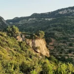
Margarites is a renowned village in the Milopotamos province, celebrated for its stunning architecture and traditional pottery. The broader region, encompassing the villages of Margarites, Orthe and Eleftherna, is characterized by a sequence of small, parallel gorges. Tiny watercourses like Margaritianos meander northwards, contributing to the Geropotamos River. These gorges are carved into the white-yellow marly limestone from the Upper Miocene era (8-10 million years ago), a result of the area’s uplift and water erosion.
The gorges’ most striking features are their abundant flora and extraordinary environment. Small groups of horizontally branched cypresses (Cupressus sempervirens var horizontal) blend with low shrubs, wildflowers, and aromatic plants. The local authorities have fashioned small trails that reveal the area’s beauty to visitors.
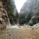
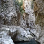
The untamed Prassano gorge, also known as the Gorge of Prasses, is situated 10 km southeast of Rethymnon. It commences south of the Prasses village and provides a captivating three-hour hike through enormous rocks and some fairly challenging passages, adding to the intrigue of the trek. The Prasano Gorge, currently serving as the “overflow” channel for the Potami dam, winds its way through the rocky hills of Gargana, with its stream terminating in the suburb of Platania, east of the city of Rethymnon. The river is engulfed by lush vegetation and towering plane trees, making it an ideal spot for a refreshing excursion.
The Prassano gorge can only be accessed from mid-June to mid-October due to the water flow. It is a crucial biotope of Crete, providing a habitat for buzzards and a small group of Bonelli’s eagles.
The Prasses Village
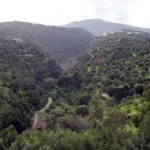
Set amidst the verdant Cretan landscape on the slopes of Vrysinas, Prasses serves as an entrance to the southern coast. This medieval village showcases the intermingling of diverse cultures that have traversed Crete, evident in the Venetian mansions, Turkish farmsteads, and Orthodox churches. The rich natural and cultural diversity make the village an ideal location for tours and walks. Heading south from Prasses, the road leads to the Potami valley, home to the dam of the same name.
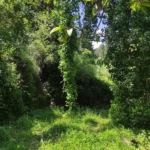
Located near the town of Rethymno, Mili Gorge is an enchanting green oasis. It’s essentially a ravine that houses a vast array of plants and trees, forming a genuine botanical garden. The gorge gathers water from the northern slopes of Mount Vrysinas, beginning north of the Chromonastiri village and south of the Xero Chorio settlement. In recent times, it has become a popular spot for hikers who enjoy the pleasant trail that spans the entire valley.
Within the heart of the canyon lies the abandoned village of Mili, named after the water mills that were once situated in the gorge. The village is split into two areas, Ano Mili (Upper mills) and Kato Mili (Lower mills). The majority of villagers were millers, with nearly all the cereals from the region and surrounding villages being milled at Mili.
Nowadays, only one renovated watermill remains in good condition for visitors to understand its operation. Besides the numerous mills, the area is home to gardens filled with fruit trees and vegetables. Water continuously flows from the springs scattered throughout the canyon, with the largest springs being Saint Anthony and Five Virgins. The water along its course forms small waterfalls and lakes, perfect for a refreshing dip under the shade of towering plane trees.
The village of Mili was deserted in 1972 due to fear of landslides, with some mills being renovated into residences and a cafe-restaurant for guests. The villagers moved and built the village Nei Mili (new mills) high above the gorge on the west. The gorge also boasts a significant number of striking churches, including the cavernous church of Saint Anthony (Agios Antonios) and the cavernous church of Saint John (Agios Ioannis), as well as the cemetery church of the Holy Five Virgins (Pente Parthenes).
Further along Kato Mili, you’ll encounter the cavernous chapels of Saint Paraskevi (Agia Paraskevi) and Saint Nicholas (Agios Nikolaos).
In northern Rethymnon, beneath the village of Myrthios (not to be confused with the Myrthios near Plakias), a petite ravine teeming with plane trees gives way to a wild and untamed gorge at Kaminolakos. The gorge is typically dry, only filling with water after significant rainfall. It is accessible only with canyoneering gear. This gorge remained unexplored until March 22, 2013, when Christopher Cheiladakis, Argyro Koghylaki, and Rudolf Riegler ventured into it for the first time, installing safety rings in the process.
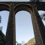
The initial stretch of the gorge is particularly wild, leading to a series of small rappels before reaching the final waterfall, a towering 55 meters high. This waterfall is nestled under an umbrella of large trees, hidden away in a shadowy enclave. The gorge culminates at the renowned stone bridge of Simas, which is situated on the road to Amari. This bridge, the highest in Crete, is considered an architectural marvel of its time.
The stunning Galliano canyon begins to the southeast of Gallos and concludes at the Rethymnon town, channeling water from the Armeni region to the Koumbes beach. It stretches over a distance of 5.5km, with the journey taking you through a lush ravine. Regrettably, there are multiple spots where shepherds have put up wires to confine their herds, making the trek along the stream challenging.
Close to the entrance, you’ll encounter the ancient Saounatsides watermill, which was operational until the 20th century. You can also see remnants of an old chapel nearby. A few meters south of the mill, another path leads to the cave-like temple of Saint Anthony.
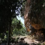
Located in the stunning province of Amari, the Patsos or Agios Antonios gorge is situated 8 km southwest of Arkadi Monastery. The gorge’s water is collected in the Potami dam. Trekking through the gorge is relatively easy up to a certain point, thanks to a well-marked trail created by the forest service. This trail concludes at the gorge’s narrowest point, where a unique waterfall cascades into a cave. Beyond this point, the gorge narrows and forms several small waterfalls. The descent to the Potami lake demands careful attention, particularly during winter and spring. Another path leads to the avifauna watchtower situated above the river.
The Patsos Gorge is renowned for Agios Antonios’ cavernous temple (Saint Anthony), which was once a sacred cave dedicated to Kraneos Hermes in ancient times. Water seeps from the rocks and drips from the temple roof, accumulating as holy water. It’s fascinating to observe the thousands of prayer papers that devotees have tucked into the rock cavities surrounding the temple. Large plateaus with wooden benches and tables, perfect for picnicking, are located beneath the temple and by the river.
The gorge derives its name from Patsos, a village nestled at the base of Mount Soros at an altitude of 490 meters. It’s approximately 30 km south of Rethymnon. The area boasts a rich variety of flora due to the numerous springs throughout the region that provide a year-round water supply.


