Margarites is a renowned village in the Milopotamos province, celebrated for its stunning architecture and traditional pottery. The broader region, encompassing the villages of Margarites, Orthe and Eleftherna, is characterized by a sequence of small, parallel gorges. Tiny watercourses like Margaritianos meander northwards, contributing to the Geropotamos River. These gorges are carved into the white-yellow marly limestone from the Upper Miocene era (8-10 million years ago), a result of the area’s uplift and water erosion.
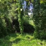
The gorges’ most striking features are their abundant flora and extraordinary environment. Small groups of horizontally branched cypresses (Cupressus sempervirens var horizontal) blend with low shrubs, wildflowers, and aromatic plants. The local authorities have fashioned small trails that reveal the area’s beauty to visitors.
The Arkadi Gorge begins just north of the Arkadi Monastery and offers a picturesque journey of approximately two hours. Certain sections along the gorge’s bed are inaccessible due to waterfalls and dense vegetation, making it possible to walk only along the eastern banks. The hiking trail concludes near the Pikris village where it joins the Gypofarago gorge. Here, visitors can appreciate significant Venetian architectural landmarks. The gorge, with its extraordinary natural beauty, allows visitors to marvel at representative species of Cretan flora and fossils.
A slim area of the gorge can also be viewed by driving to the Arkadi Monastery, as the roadway runs through it. This means you can get a sense of its appearance just by visiting the monastery.
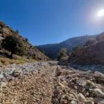
The Zoniana canyon is situated to the south of Zoniana village within the Psiloritis Range. It begins at a height of 950m, gathering water from several streams that flow from the Zoniana mountains, and concludes at the village at a height of 650m. The “serpentine” river Oaxis, which carries water until spring and ultimately drains into the Geropotamos river, flows through this gorge.
This gorge is not only easily accessible but also safe for hiking due to its gentle slope. The rock formations in many areas are truly remarkable, made up of numerous layers, and there are stunning geological structures and trees clinging to the steep slopes and narrow points. As it nears the village, the canyon broadens and morphs into a slender valley.
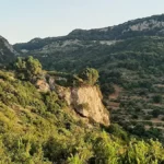
The Platania Gorge, positioned above the Platania village, links the southeast slopes of the Psiloritis range to the Amari valley, approximately 38km southeast of Rethymno. The river flowing through it collects water from the west of the Migia (1584m) and Spathi (1779m) peaks and channels it to the River Platys, which terminates in Agia Galini. A challenging yet secure trail winds its way up to the starting point at Kokkinoharako, skirting its steep slopes. The trail provides hikers with breathtaking views of the towering cliffs, vertical limestone rocks displaying yellow-red hues of erosion, rock shelters, and numerous caves.
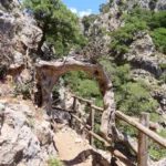
At roughly 800m altitude, a small plateau hosts the cave-like church of Saint Anthony (Agios Antonios), constructed near a spring. The trail from Agios Antonios continues its ascent northwest, meeting a dirt road originating from the Vistagi village. On the opposite side of the gorge, in the east, lies the Panas cave, named after the ancient god Pan, god of the wild, shepherds, and flocks, who, as per local folklore, was born here. The cave houses petroglyphs from the Minoan era, indicating continuous worship at the site. The same dirt road from Vistagi provides access to the nearby church of Saint Mammes (Agios Mamas), the patron saint of shepherds in Christianity.
The Platania Gorge’s interior is stunning, though few get to witness it due to its steep waterfalls, which require technical canyoning equipment to navigate. The tallest waterfall stands at approximately 40m. The first known crossing of the gorge was in 2008 by the canyoning group of Giannis Bromirakis and Christoforos Cheiladakis. The cliffs provide a nesting habitat for various bird species, including vultures, hawks, wild pigeons, and crows.


