Situated 13km west of Rethymno, Petres Gorge opens up at the Petres beach. It houses the longest river in Rethymnon province, which is replenished by multiple tributaries that gather the waters of Kollita Gorges from the west to Mount Vrysinas in the east, spanning almost half of Rethymnon Prefecture. The river flows throughout the year and forms a significant wetland of Crete, particularly near its mouth at Episkopi.
The gorge narrows down to a small section about 1km long, beginning near the village of Karoti. Despite its short length, it is definitely worth exploring. It is easily accessible and perfect for swimming in the ponds that form along its course. However, fences are installed to confine goats, so carrying a cutter might be useful in case the fences are locked. Certain areas with large rocks may require a bit of climbing and extra caution.
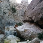
The Twin Ravines, or Kollita Gorges, can be found near the charming village of Argyroupolis, approximately 22km southwest of the city of Rethymnon. The name refers to the two parallel canyons that conclude near the village of Kato Poros. The easternmost canyon, Moundros Gorge, is bordered by the Vigla peak (567m) to the east and the Nissiani hill to the west, where you can find the abandoned settlement of Nissi. Adjacent to Moundros Gorge to the west, is the Vilandredo Gorge, named after the village at its entrance and often referred to as Kollita Gorge.
The gorges offer an ideal hiking experience for novices due to their ease and stunning surroundings. It’s a perfect outing for groups of friends – park your car in Kato Poros or Argyroupolis, explore the Moundriano canyon, and return via the second Kollita Gorge for a round trip.
A suggested itinerary for the two gorges starts in the verdant Argiroupoli, built on the site of the ancient city of Lappa. From there, head east to the village of Moundros, known for its springs, fountains, and beautiful Venetian architecture. Don’t miss a stroll through the narrow streets of Moundros and a visit to the churches of Saint Constantine, Saints Anargyri (11th century), and Saint Nicholas. Near Moundros, you’ll find the deserted settlement of Nissi, notable for its impressive stone structures.
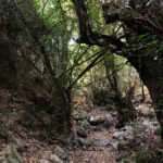
From the village, make your way to the northern entrance of the lush Moundros Gorge, which leads to the village of Velonado. A well-marked path descends to the riverbed, which is typically full of water. The canyon boasts towering plane trees and several freshwater ponds. After about a 1.5-hour walk, you’ll reach the southern entrance of Moundriano Gorge near Velonado.
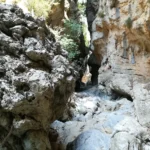
Exiting the canyon, head west on the asphalt road to the entrance of the second canyon, Kollita Gorge, near Vilandredo. This canyon is even more impressive than Moundriano, filled with plane trees and a path that runs along the riverbed. The most breathtaking part of the canyon is where its towering walls nearly touch, creating a very narrow passage. Along the slopes of the gorge, you’ll spot numerous fig and holly trees. After a total of four hours, you’ll exit the canyon, which once supplied water to the Roman baths of Lappa, now Argyroupolis.
Following the old stone path amidst laurels, myrtles, and hollies, you’ll reach Kato Poros and the area of Pente Parthenes (Five Virgins). Here, you’ll find a spring under the perennial plane tree of Pente Parthenes, the chapel of the Five Virgins, and the Hellenistic and Roman tombs of Lappa. From here, the trail broadens and leads back to the lush green Argiroupoli. In Argiroupoli, be sure to visit the Venetian buildings, churches, and picturesque alleyways. The springs of Argyroupolis are a popular attraction, particularly the spring in the cavernous chapel of Agia Dynami. The area is lush with several small waterfalls and numerous restaurants.
The Twin Ravines, or Kollita Gorges, are situated near the scenic village of Argyroupolis, approximately 22km southwest of the city of Rethymnon. The name derives from two adjacent canyons that conclude near the village of Kato Poros. The eastern canyon, Moundros Gorge, is bordered by the Vigla peak (567m) to the east and Nissiani hill to the west, which houses the deserted Nissi settlement. West of Moundros gorge lies the Vilandredo gorge, named after the village at its entrance and more commonly referred to as Kollita Gorge.
These gorges are perfect for casual hikers due to their ease and stunning beauty. They are particularly suitable for groups of friends who can park in Kato Poros or Argyroupoli, explore the Moundriano canyon, and return via the second Kollita Gorge.
Suggested Two Gorges Route
Starting from the verdant Argiroupoli, built on the ancient city of Lappa, we journey east to the village of Moundros, known for its springs and fountains. The village is home to many beautiful Venetian structures (old courts, prisons, and noble houses) and the churches of Saint Constantine, Saints Anargyri (11th century), and Saint Nicholas are well worth a visit. Don’t forget to wander the narrow streets of Moundros. Close to Moundros, the deserted Nissi settlement, famous for its stunning stone structures, can be found.
From the village, the entrance to the verdant Moundros gorge is accessible, leading to the village of Velonado. A well-defined path descends to the riverbed, which is usually filled with water. The canyon is filled with towering plane trees and several fresh water ponds. After roughly 1.5 hours of walking, we reach the southern entrance of Moundriano Gorge, near Velonado.
Upon exiting the canyon, we follow the asphalt road west to the entrance of the second canyon, Kollita Gorge, near Vilandredo. This canyon, more magnificent than Moundriano, is lush with plane trees, and the path follows the riverbed. The most beautiful section of the canyon is where the high walls nearly touch, forming a narrow passage. Fig and holly trees can be seen on the gorge’s slopes, hanging overhead. After approximately four hours, we exit the canyon, which once provided water for the Roman baths of Lappa, now Argyroupolis.
Following the ancient stone path through laurels, myrtles, and hollies, we reach Kato Poros and the area of Pente Parthenes (Five Virgins). Here, one can find the spring beneath the perennial plane tree of Pente Parthenes, the chapel of the Five Virgins, and the Hellenistic and Roman tombs of Lappa. From here, the trail broadens and leads us back to the lush green Argiroupoli. In Argiroupoli, the Venetian buildings, churches, and picturesque alleys are worth a visit. A popular attraction is the springs of Argyroupolis, with the most notable spring located in the cavernous chapel of Agia Dynami. The area is lush with several small waterfalls and numerous restaurants.
The stunning Galliano canyon begins to the southeast of Gallos and concludes at the Rethymnon town, channeling water from the Armeni region to the Koumbes beach. It stretches over a distance of 5.5km, with the journey taking you through a lush ravine. Regrettably, there are multiple spots where shepherds have put up wires to confine their herds, making the trek along the stream challenging.
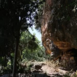
Close to the entrance, you’ll encounter the ancient Saounatsides watermill, which was operational until the 20th century. You can also see remnants of an old chapel nearby. A few meters south of the mill, another path leads to the cave-like temple of Saint Anthony.
No results available
ResetNo results available
Reset© All rights reserved. Crete Locals


