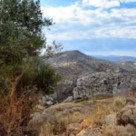
In the quiet, almost abandoned village of Chordaki, located in the Amari district, we discovered the hidden gem of Kynigospilios Canyon. Situated south of the village, this small but stunning canyon remains a secret, its location hidden from view, which contributes to its relative obscurity. The Kynigospilios Canyon boasts a significant water flow from the slopes of Mount Kedros, which lasts from winter through to late spring.
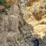
However, traversing the canyon requires the use of ropes and canyoning equipment due to the presence of eight stunning waterfalls along its path, with the last one being particularly breathtaking. Unfortunately, the canyon’s safety measures, installed by canyoners around 2011, are not ideally positioned, making them inaccessible during periods of high water flow. The canyon was christened ‘Koutsouna’ (meaning ‘small’) by the first group to cross it, as they couldn’t find an existing name for it.
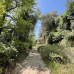
At the canyon’s entrance, you’ll find two adjacent watermills, and the surrounding area is lush with greenery, including platans and oaks that provide ample shade. Beneath most of the waterfalls, you’ll find ponds perfect for swimming in the canyon’s crystal-clear river waters. The Kynigospilios Canyon eventually merges into the Platys River bed at its termination point.
On the southeastern flank of Mount Sanida, near the quaint village of Skourvoula, you’ll find a petite yet wildly untamed chasm known as Rizopetro. This gorge culminates in a striking 60m waterfall that cascades into the lake of the Faneromeni dam, a sight to behold especially after heavy downpours.
The Apolychnos Gorge, situated just a few kilometers north of the town of Mires, is nestled in an area abundant with olive groves. This gorge is essentially a narrow valley that traces the path of a river, which in certain areas deepens and is surrounded by thick vegetation. The Tourki stream that flows through it carries water from a valley that begins west of Makres village to the Geropotamos river. The gorge, which is roughly 3 km long, begins near the village of Panagia and concludes at the traditional settlement of Agios Antonios (Vrelis). It’s conveniently accessible, particularly near its exit close to Agios Antonios, as it’s adjacent to the main road from Mires.
The gorge is named after the deserted village of Apolychnos, which is situated within the gorge at an elevation of 220m. This village, enveloped by verdant trees and bubbling springs, is home to the stunning Byzantine church of Saint Panteleimon, located in the village square.


